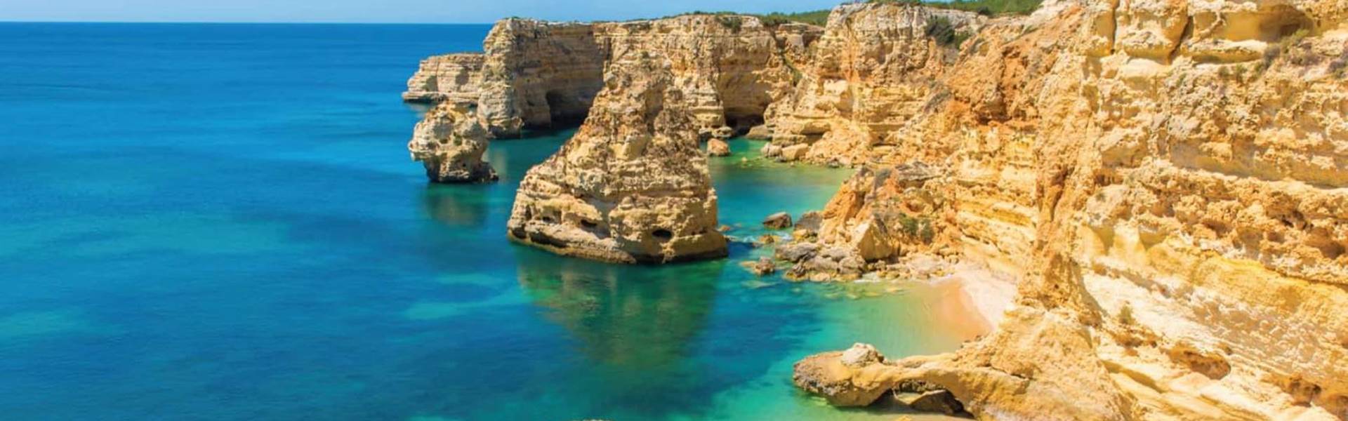
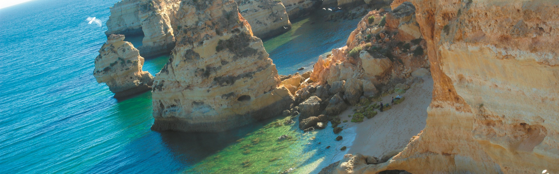
Tavira & Ria Formosa
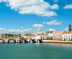
Tavira, architectural beauty of the Eastern Algarve. Tavira has some of the most interesting architecture in the whole of the Algarve. Its origin dates back to the year 2000 BC. and even at the time of the Arab occupation, fishing was of great importance here. In the 17th century, the port, located on the banks of the River Gilão, was an important place for the transhipment of wine, salt and dried fish. After the 1755 earthquake, Tavira was completely rebuilt, and – in addition to many beautiful buildings with 17th century architecture. XVIII – 37 churches appeared. The Church of Santa Maria do Castelo was built where a mosque once stood. The surroundings of Tavira are still agricultural, although the municipality has been adapting to the demands of tourism in recent times. Ilha de Tavira opposite Tavira belongs to the chain of barrier islands in the Ria Formosa that stretches between Faro and Cacela-a-Velha east of Tavira and protects the unique lagoon system against the force of the Atlantic Ocean. Access to the beach on Ilha de Tavira is only possible via the ferry boats that take visitors to and from the sandbank. Ilha de Tavira stretches along the coast between the small village called Luz de Tavira to the northeast until reaching Tavira. The famous Praia do Barril is located in the center of the island. Access from the coast at Pedras d’el Rei is via a small bridge and a 1 km route on foot or on a small train. The former fishermen's warehouses were transformed into support infrastructure, such as bathrooms, shops and restaurants. Next to it, a row of anchors on the dunes are testimony to the glorious past of the Algarve and tuna fishing when these anchors fixed the nets to the bottom of the sea. Further east, the island becomes narrower and the small Praia de Santa Luzia is only 50 m wide, also known as Praia da Terra Estreita. There is an official nudist beach on Ilha de Tavira, Praia da Homem Nu on the west side of the island
Loulé
Loulé the largest district in the Algarve, Portugal Loulé is an important rural administrative and active market town. The weekly fair attracts tourists from all over the Algarve. The town's landmark is the market hall (Mercado municipal) which re-opened in early 2007 after a long period of renovation. Its architecture has a classic moorish style influence. Today you can only see some remains of the Arab castle and the Gothic Church of S. Clemente. The town is nevertheless worth a visit, especially the old part and its surroundings The annual Carnival in February with itsa colourful procession around the centre of the city is considered one of the best in Portugal. In the summer enjoy the White Night, a night street party in the city centre decorated in white and where visitors from all over the Algarve come to join in, dressed in white. Loulé also host a Halloween parade at night, where everyone participates in the fun “horror”.
Sagres & Aljezur
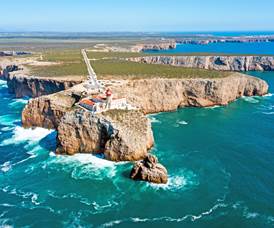
Sagres the most south-western corner of the Algarve, Portugal The village of Sagres in the district of Vila do Bispo is situated on Europe's most south-western corner near Cabo do São Vicente. It was this exposed location that made Sagres the starting point of numerous expeditions during past centuries. The age of the Portuguese Discoveries began back in the 15th century, initiated by Henry the Navigator. Cabo de São Vicente (Cape St.Vincent) and the Ponta de Sagres together form the south-western corner of the European continent. The cape consists of a steep cliff of about 69 m with almost no vegetation. The Fortaleza de Sagres (Fortress of Sagres), located south-west of Sagres on a small headland about 1 km in length, is a monument of national importance. After passing through the thick tunnel entrance, one sees a giant pebble circle , detected only in 1921, of unknown age and purpose. The circle with a diameter of 43m is interpreted as a compass rose (Rosa dos Ventos). Normally compass roses are divided into 32 segments, but strangely this one has 40 segments, so it could also have been a sundial. Most likely it dates back to the time of Henry the Navigator. Reserva Biogenética de Sagres: as one of Southern Europe’s last remaining and most important stretches of wild, unspoilt coastline, benefiting from both a low level of human interference and a low population density, the area from Ponta de Sagres to Cape St. Vincent is a protected area filled with a wide biodiversity of different species and natural habitats, many of which are quite unique in the world. The area around Sagres is quite inhospitable due to the constant strong winds blowing from the Atlantic Ocean. Nevertheless, this historical location attracts tourists from all over the world throughout the year. Aljezur situated in the Costa Vicentina natural park on the Algarve’s west coast, Portugal. Aljezur is a small market town with two parts divided by a fertile river val
Vila Real de S. António
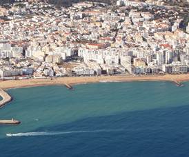
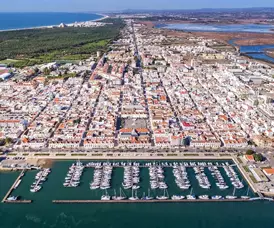
Vila Real de Santo António, located on the border with Spain, was from its origins - probably in Phoenician times - a small fishing port. After the 1755 earthquake, the city was completely designed and built by the Marquis of Pombal, an influential minister of D. José I, King of Portugal (1750-1777), who also ordered the construction of the new center of Lisbon. The popular tourist town of Monte Gordo, located on the coast and 5 km west of the center of Vila Real, offers vacationers extensive white sand beaches surrounded by pine forests. The comfortable crossing of the Guadiana river by ferry to the picturesque town of Ayamonte, on the Spanish bank, is a pleasant alternative programme. Another recommended trip is to go up the river to the small town of Alcoutim. The origin of the region around Alcoutim dates back to the megalithic era, around 4000 years before Christ.